


brambois

randolea
User
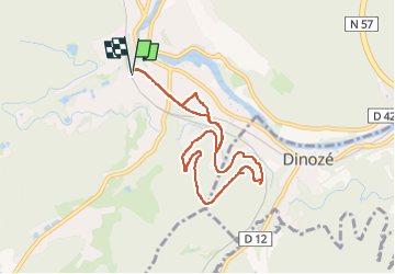

Length
7.8 km

Max alt
481 m

Uphill gradient
166 m
Km-Effort
10 km

Min alt
343 m

Downhill gradient
167 m
Boucle
Yes
Creation date :
2024-02-29 08:42:09.199
Updated on :
2024-02-29 10:52:53.204
1h57
Difficulty : Medium

FREE GPS app for hiking
 SityTrail
IGN / Geographical institutes
SityTrail Plus
The world is yours!
About
Trail Walking of 7.8 km to be discovered at Grand Est, Vosges, Épinal. This trail is proposed by randolea.
Positioning
Country:
France
Region :
Grand Est
Department/Province :
Vosges
Municipality :
Épinal
Location:
Unknown
Start:(Dec)
Start:(UTM)
310291 ; 5336071 (32U) N.
Comments