


limonest

janussity
User
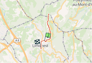

Length
4.5 km

Max alt
561 m

Uphill gradient
141 m
Km-Effort
6.5 km

Min alt
386 m

Downhill gradient
176 m
Boucle
No
Creation date :
2024-02-29 14:00:45.701
Updated on :
2024-02-29 15:17:12.286
1h06
Difficulty : Very easy

FREE GPS app for hiking
 SityTrail
IGN / Geographical institutes
SityTrail Plus
The world is yours!
About
Trail Walking of 4.5 km to be discovered at Auvergne-Rhône-Alpes, Métropole de Lyon, Limonest. This trail is proposed by janussity.
Description
avec Olivia
Positioning
Country:
France
Region :
Auvergne-Rhône-Alpes
Department/Province :
Métropole de Lyon
Municipality :
Limonest
Location:
Unknown
Start:(Dec)
Start:(UTM)
637745 ; 5077570 (31T) N.
Comments