


Venterol

raygautier
User
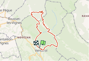

Length
17.4 km

Max alt
868 m

Uphill gradient
889 m
Km-Effort
29 km

Min alt
404 m

Downhill gradient
890 m
Boucle
Yes
Creation date :
2024-02-29 08:35:17.0
Updated on :
2024-02-29 16:22:44.903

FREE GPS app for hiking
 SityTrail
IGN / Geographical institutes
SityTrail Plus
The world is yours!
About
Trail of 17.4 km to be discovered at Auvergne-Rhône-Alpes, Drôme, Venterol. This trail is proposed by raygautier.
Positioning
Country:
France
Region :
Auvergne-Rhône-Alpes
Department/Province :
Drôme
Municipality :
Venterol
Location:
Unknown
Start:(Dec)
Start:(UTM)
667044 ; 4917457 (31T) N.
Comments