


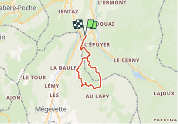
Tour des Jottis

DaVinci
User

Length
10.3 km

Max alt
1413 m

Uphill gradient
555 m
Km-Effort
17.7 km

Min alt
1030 m

Downhill gradient
557 m
Boucle
Yes
Creation date :
2024-03-01 09:05:30.694
Updated on :
2024-03-01 11:18:38.504
2h12
Difficulty : Difficult

FREE GPS app for hiking
 SityTrail
IGN / Geographical institutes
SityTrail Plus
The world is yours!
About
Trail Walking of 10.3 km to be discovered at Auvergne-Rhône-Alpes, Upper Savoy, Bellevaux. This trail is proposed by DaVinci.
Positioning
Country:
France
Region :
Auvergne-Rhône-Alpes
Department/Province :
Upper Savoy
Municipality :
Bellevaux
Location:
Unknown
Start:(Dec)
Start:(UTM)
308974 ; 5123166 (32T) N.
Comments