


MARTAGNY Les DUPRES

serge.guerroult
User
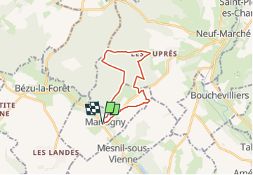

Length
9.8 km

Max alt
189 m

Uphill gradient
160 m
Km-Effort
12 km

Min alt
103 m

Downhill gradient
160 m
Boucle
Yes
Creation date :
2024-03-01 18:55:11.482
Updated on :
2024-03-01 18:56:20.043
0m
Difficulty : Very easy

FREE GPS app for hiking
 SityTrail
IGN / Geographical institutes
SityTrail Plus
The world is yours!
About
Trail Nordic walking of 9.8 km to be discovered at Normandy, Eure, Martagny. This trail is proposed by serge.guerroult.
Positioning
Country:
France
Region :
Normandy
Department/Province :
Eure
Municipality :
Martagny
Location:
Unknown
Start:(Dec)
Start:(UTM)
402604 ; 5472146 (31U) N.
Comments
a faire si il pleut l'aveil