


autour de LAROQUE

stef789
User GUIDE
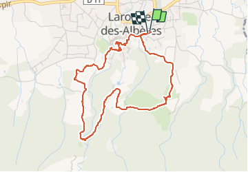

Length
5.1 km

Max alt
194 m

Uphill gradient
104 m
Km-Effort
6.5 km

Min alt
107 m

Downhill gradient
105 m
Boucle
Yes
Creation date :
2024-03-03 15:45:19.626
Updated on :
2024-03-03 17:46:43.081
2h00
Difficulty : Easy

FREE GPS app for hiking
 SityTrail
IGN / Geographical institutes
SityTrail Plus
The world is yours!
About
Trail Walking of 5.1 km to be discovered at Occitania, Pyrénées-Orientales, Laroque-des-Albères. This trail is proposed by stef789.
Photos


39 photos in total. Please click on a photo to see them all in the gallery.
Positioning
Country:
France
Region :
Occitania
Department/Province :
Pyrénées-Orientales
Municipality :
Laroque-des-Albères
Location:
Unknown
Start:(Dec)
Start:(UTM)
494838 ; 4707750 (31T) N.
Comments