


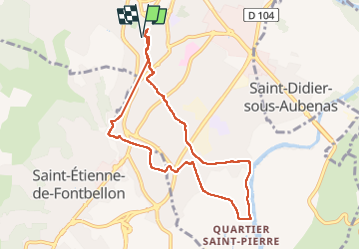
4 /03/24 Voie verte St Étienne-Ardèche

Linerou
User

Length
8.5 km

Max alt
288 m

Uphill gradient
126 m
Km-Effort
10.1 km

Min alt
170 m

Downhill gradient
123 m
Boucle
Yes
Creation date :
2024-03-04 08:24:03.248
Updated on :
2024-03-04 10:57:51.266
2h06
Difficulty : Easy

FREE GPS app for hiking
 SityTrail
IGN / Geographical institutes
SityTrail Plus
The world is yours!
About
Trail Walking of 8.5 km to be discovered at Auvergne-Rhône-Alpes, Ardèche, Aubenas. This trail is proposed by Linerou.
Positioning
Country:
France
Region :
Auvergne-Rhône-Alpes
Department/Province :
Ardèche
Municipality :
Aubenas
Location:
Unknown
Start:(Dec)
Start:(UTM)
610197 ; 4941126 (31T) N.
Comments