


Le Beisseil

micheldutilleul
User

Length
6.2 km

Max alt
1447 m

Uphill gradient
215 m
Km-Effort
9.1 km

Min alt
1303 m

Downhill gradient
217 m
Boucle
Yes
Creation date :
2024-03-05 13:22:10.258
Updated on :
2024-03-06 19:16:50.805
1h33
Difficulty : Medium

FREE GPS app for hiking
 SityTrail
IGN / Geographical institutes
SityTrail Plus
The world is yours!
About
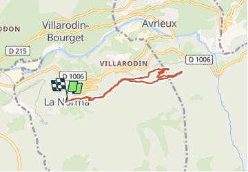
Trail Walking of 6.2 km to be discovered at Auvergne-Rhône-Alpes, Savoy, Villarodin-Bourget. This trail is proposed by micheldutilleul.
Positioning
Country:
France
Region :
Auvergne-Rhône-Alpes
Department/Province :
Savoy
Municipality :
Villarodin-Bourget
Location:
Unknown
Start:(Dec)
Start:(UTM)
319107 ; 5007887 (32T) N.
Comments