


champ du feu - Rothau

Titinechris
User
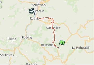

Length
12.7 km

Max alt
1075 m

Uphill gradient
346 m
Km-Effort
19.7 km

Min alt
344 m

Downhill gradient
1074 m
Boucle
No
Creation date :
2024-03-05 16:16:11.881
Updated on :
2024-03-05 16:17:53.74
4h29
Difficulty : Very difficult

FREE GPS app for hiking
 SityTrail
IGN / Geographical institutes
SityTrail Plus
The world is yours!
About
Trail Walking of 12.7 km to be discovered at Grand Est, Bas-Rhin, Belmont. This trail is proposed by Titinechris.
Description
visite du camp de concentration
Positioning
Country:
France
Region :
Grand Est
Department/Province :
Bas-Rhin
Municipality :
Belmont
Location:
Unknown
Start:(Dec)
Start:(UTM)
371914 ; 5362489 (32U) N.
Comments