


L’Écureuil (descente)

micheldutilleul
User

Length
5.6 km

Max alt
1833 m

Uphill gradient
46 m
Km-Effort
7.7 km

Min alt
1354 m

Downhill gradient
480 m
Boucle
No
Creation date :
2024-03-06 12:56:18.743
Updated on :
2024-03-06 19:08:22.468
2h14
Difficulty : Very easy

FREE GPS app for hiking
 SityTrail
IGN / Geographical institutes
SityTrail Plus
The world is yours!
About
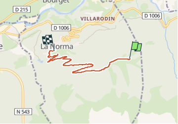
Trail Snowshoes of 5.6 km to be discovered at Auvergne-Rhône-Alpes, Savoy, Villarodin-Bourget. This trail is proposed by micheldutilleul.
Positioning
Country:
France
Region :
Auvergne-Rhône-Alpes
Department/Province :
Savoy
Municipality :
Villarodin-Bourget
Location:
Unknown
Start:(Dec)
Start:(UTM)
321110 ; 5007542 (32T) N.
Comments