


aux environs de Port-Vendres

stef789
User GUIDE
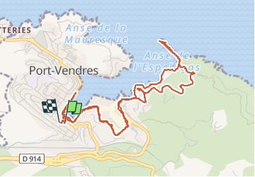

Length
7 km

Max alt
55 m

Uphill gradient
105 m
Km-Effort
8.4 km

Min alt
-1 m

Downhill gradient
103 m
Boucle
Yes
Creation date :
2024-03-07 14:21:05.727
Updated on :
2024-03-07 16:10:15.946
1h48
Difficulty : Easy

FREE GPS app for hiking
 SityTrail
IGN / Geographical institutes
SityTrail Plus
The world is yours!
About
Trail Walking of 7 km to be discovered at Occitania, Pyrénées-Orientales, Port-Vendres. This trail is proposed by stef789.
Photos


Positioning
Country:
France
Region :
Occitania
Department/Province :
Pyrénées-Orientales
Municipality :
Port-Vendres
Location:
Unknown
Start:(Dec)
Start:(UTM)
508689 ; 4707032 (31T) N.
Comments