


20240309-l'Essart Mador

doudet
User
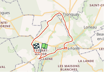

Length
13.1 km

Max alt
181 m

Uphill gradient
223 m
Km-Effort
16.1 km

Min alt
78 m

Downhill gradient
221 m
Boucle
Yes
Creation date :
2024-03-09 12:46:53.798
Updated on :
2024-03-13 07:33:21.009
3h05
Difficulty : Medium

FREE GPS app for hiking
 SityTrail
IGN / Geographical institutes
SityTrail Plus
The world is yours!
About
Trail Walking of 13.1 km to be discovered at Normandy, Eure, Lyons-la-Forêt. This trail is proposed by doudet.
Description
Boucle A-R au départ de la Chapelle St Jean
Photos


48 photos in total. Please click on a photo to see them all in the gallery.
Positioning
Country:
France
Region :
Normandy
Department/Province :
Eure
Municipality :
Lyons-la-Forêt
Location:
Unknown
Start:(Dec)
Start:(UTM)
387182 ; 5472619 (31U) N.
Comments