


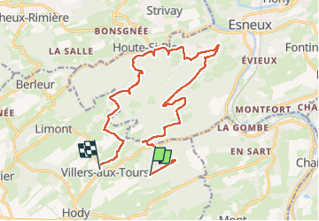
Villers aux tours
© OpenStreetMap contributors


5h45
Difficulty : Unknown


Length
16.5 km
Max alt
298 m
Uphill gradient
395 m
Km-Effort
22 km
Min alt
122 m
Downhill gradient
431 m
Boucle
No
Creation date :
2024-03-10 09:35:45.0
Updated on :
2024-03-10 15:21:45.444
5h45
Difficulty : Unknown
FREE GPS app for hiking
 SityTrail
IGN / Geographical institutes
SityTrail Plus
The world is yours!
About
Trail Walking of 16.5 km to be discovered at Wallonia, Liège, Anthisnes. This trail is proposed by gabydeleu@hotmail.com.
Description
Marche
Positioning
Country:
Belgium
Region :
Wallonia
Department/Province :
Liège
Municipality :
Anthisnes
Location:
Unknown
Start:(Dec)
Start:(UTM)
679428 ; 5596847 (31U) N.
Comments