


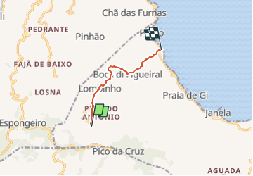
île de Santo Antão - Vila das Pombas - Vallée de Paul

jeanmarcMasson
User GUIDE

Length
7.7 km

Max alt
630 m

Uphill gradient
48 m
Km-Effort
10.4 km

Min alt
5 m

Downhill gradient
665 m
Boucle
No
Creation date :
2024-03-10 20:30:06.051
Updated on :
2024-03-10 20:33:20.058
2h22
Difficulty : Medium

FREE GPS app for hiking
 SityTrail
IGN / Geographical institutes
SityTrail Plus
The world is yours!
About
Trail Walking of 7.7 km to be discovered at Unknown, Paul. This trail is proposed by jeanmarcMasson.
Positioning
Country:
Cape Verde
Region :
Unknown
Department/Province :
Paul
Municipality :
Unknown
Location:
Unknown
Start:(Dec)
Start:(UTM)
707624 ; 1893226 (26Q) N.
Comments