monterminod 11 mars 2025

pierrounet
User
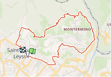

Length
7.1 km

Max alt
603 m

Uphill gradient
324 m
Km-Effort
11.4 km

Min alt
297 m

Downhill gradient
323 m
Boucle
Yes
Creation date :
2024-03-11 12:04:26.299
Updated on :
2024-03-11 14:31:40.463
2h26
Difficulty : Medium

FREE GPS app for hiking
 SityTrail
IGN / Geographical institutes
SityTrail Plus
The world is yours!
About
Trail Walking of 7.1 km to be discovered at Auvergne-Rhône-Alpes, Savoy, Saint-Alban-Leysse. This trail is proposed by pierrounet.
Positioning
Country:
France
Region :
Auvergne-Rhône-Alpes
Department/Province :
Savoy
Municipality :
Saint-Alban-Leysse
Location:
Unknown
Start:(Dec)
Start:(UTM)
730747 ; 5051677 (31T) N.
Comments