


la rippe 13 mars 24

pierrounet
User

Length
9.8 km

Max alt
969 m

Uphill gradient
404 m
Km-Effort
15.2 km

Min alt
643 m

Downhill gradient
413 m
Boucle
Yes
Creation date :
2024-03-13 12:24:07.546
Updated on :
2024-03-13 15:22:40.079
2h57
Difficulty : Difficult

FREE GPS app for hiking
 SityTrail
IGN / Geographical institutes
SityTrail Plus
The world is yours!
About
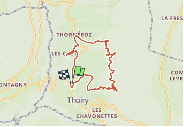
Trail Walking of 9.8 km to be discovered at Auvergne-Rhône-Alpes, Savoy, Thoiry. This trail is proposed by pierrounet.
Positioning
Country:
France
Region :
Auvergne-Rhône-Alpes
Department/Province :
Savoy
Municipality :
Thoiry
Location:
Unknown
Start:(Dec)
Start:(UTM)
268285 ; 5052811 (32T) N.
Comments