


Chantilly Senlis Fleurines

pierrol
User
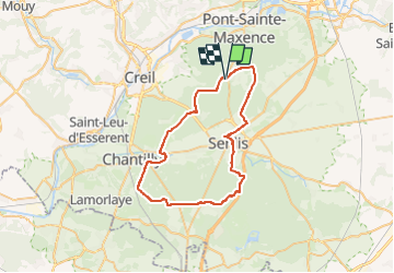

Length
46 km

Max alt
156 m

Uphill gradient
478 m
Km-Effort
52 km

Min alt
41 m

Downhill gradient
474 m
Boucle
Yes
Creation date :
2024-03-14 08:04:25.469
Updated on :
2024-03-14 08:04:26.851
3h37
Difficulty : Very difficult

FREE GPS app for hiking
 SityTrail
IGN / Geographical institutes
SityTrail Plus
The world is yours!
About
Trail Mountain bike of 46 km to be discovered at Hauts-de-France, Oise, Fleurines. This trail is proposed by pierrol.
Positioning
Country:
France
Region :
Hauts-de-France
Department/Province :
Oise
Municipality :
Fleurines
Location:
Unknown
Start:(Dec)
Start:(UTM)
469599 ; 5456288 (31U) N.
Comments