


2024-03-15_08h26m47_ITILAR034V528STT (2)

Nathalie. Mercier
User
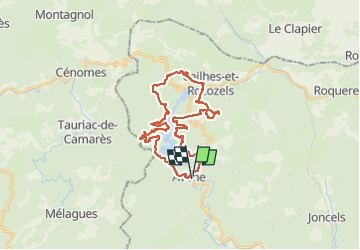

Length
34 km

Max alt
753 m

Uphill gradient
1189 m
Km-Effort
49 km

Min alt
369 m

Downhill gradient
1189 m
Boucle
Yes
Creation date :
2024-03-15 07:26:47.738
Updated on :
2024-03-15 07:26:49.53

FREE GPS app for hiking
 SityTrail
IGN / Geographical institutes
SityTrail Plus
The world is yours!
About
Trail of 34 km to be discovered at Occitania, Hérault, Avène. This trail is proposed by Nathalie. Mercier.
Positioning
Country:
France
Region :
Occitania
Department/Province :
Hérault
Municipality :
Avène
Location:
Unknown
Start:(Dec)
Start:(UTM)
508172 ; 4844861 (31T) N.
Comments