


Lux , bords de Saone , etang et retour

jeanpaulcheyssac
User
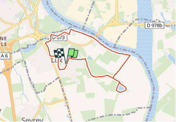

Length
7.8 km

Max alt
190 m

Uphill gradient
70 m
Km-Effort
8.7 km

Min alt
161 m

Downhill gradient
70 m
Boucle
Yes
Creation date :
2024-03-15 09:41:28.655
Updated on :
2025-02-13 12:13:51.259
1h59
Difficulty : Easy

FREE GPS app for hiking
 SityTrail
IGN / Geographical institutes
SityTrail Plus
The world is yours!
About
Trail On foot of 7.8 km to be discovered at Bourgogne-Franche-Comté, Saône-et-Loire, Lux. This trail is proposed by jeanpaulcheyssac.
Positioning
Country:
France
Region :
Bourgogne-Franche-Comté
Department/Province :
Saône-et-Loire
Municipality :
Lux
Location:
Unknown
Start:(Dec)
Start:(UTM)
641525 ; 5179254 (31T) N.
Comments