


Entre Ittre et Haut-Ittre, le long du Ry Ternel (routedans le

samlrando
User
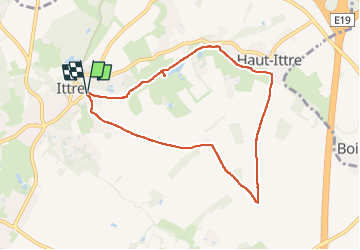

Length
7 km

Max alt
143 m

Uphill gradient
87 m
Km-Effort
8.1 km

Min alt
75 m

Downhill gradient
87 m
Boucle
Yes
Creation date :
2024-03-16 09:12:58.0
Updated on :
2024-03-18 13:08:28.907

FREE GPS app for hiking
 SityTrail
IGN / Geographical institutes
SityTrail Plus
The world is yours!
About
Trail of 7 km to be discovered at Wallonia, Walloon Brabant, Ittre. This trail is proposed by samlrando.
Description
1/3 de routes piétonnes, cyclistes et cavaliers
Beau panorama
Positioning
Country:
Belgium
Region :
Wallonia
Department/Province :
Walloon Brabant
Municipality :
Ittre
Location:
Ittre
Start:(Dec)
Start:(UTM)
589544 ; 5611626 (31U) N.
Comments