


Forest park, Springfiel, MA

bavort
User
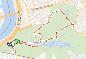

Length
6.7 km

Max alt
67 m

Uphill gradient
109 m
Km-Effort
8.1 km

Min alt
17 m

Downhill gradient
108 m
Boucle
Yes
Creation date :
2024-03-17 15:48:09.0
Updated on :
2024-03-17 17:37:01.679
1h32
Difficulty : Very easy

FREE GPS app for hiking
 SityTrail
IGN / Geographical institutes
SityTrail World
The world is yours!
About
Trail Walking of 6.7 km to be discovered at Massachusetts, Hampden County, Unknown. This trail is proposed by bavort.
Photos

Positioning
Country:
United States
Region :
Massachusetts
Department/Province :
Hampden County
Municipality :
Unknown
Location:
Springfield
Start:(Dec)
Start:(UTM)
700089 ; 4660697 (18T) N.
Comments
Trails nearby