


ps pointe de l'aiguille

psester
User
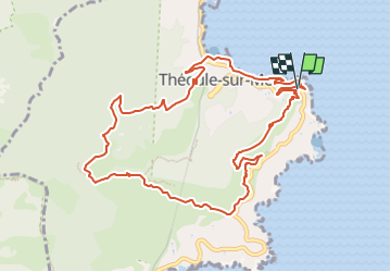

Length
11.6 km

Max alt
257 m

Uphill gradient
436 m
Km-Effort
17.4 km

Min alt
0 m

Downhill gradient
423 m
Boucle
Yes
Creation date :
2024-03-18 08:49:25.605
Updated on :
2024-04-08 16:52:21.521
3h56
Difficulty : Difficult

FREE GPS app for hiking
 SityTrail
IGN / Geographical institutes
SityTrail Plus
The world is yours!
About
Trail Walking of 11.6 km to be discovered at Provence-Alpes-Côte d'Azur, Maritime Alps, Théoule-sur-Mer. This trail is proposed by psester.
Positioning
Country:
France
Region :
Provence-Alpes-Côte d'Azur
Department/Province :
Maritime Alps
Municipality :
Théoule-sur-Mer
Location:
Unknown
Start:(Dec)
Start:(UTM)
334477 ; 4818930 (32T) N.
Comments