


Le Poulailler-Groslay-St François-Chénedet 18,5km JY

COGLAIS3
User
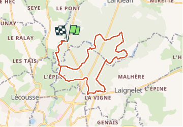

Length
18.5 km

Max alt
206 m

Uphill gradient
337 m
Km-Effort
23 km

Min alt
110 m

Downhill gradient
336 m
Boucle
Yes
Creation date :
2024-03-19 07:11:59.825
Updated on :
2024-03-19 20:45:05.427
3h24
Difficulty : Easy

FREE GPS app for hiking
 SityTrail
IGN / Geographical institutes
SityTrail Plus
The world is yours!
About
Trail Nordic walking of 18.5 km to be discovered at Brittany, Ille-et-Vilaine, Landéan. This trail is proposed by COGLAIS3.
Positioning
Country:
France
Region :
Brittany
Department/Province :
Ille-et-Vilaine
Municipality :
Landéan
Location:
Unknown
Start:(Dec)
Start:(UTM)
634073 ; 5361591 (30U) N.
Comments