


a53-calanques

Jack-94
User
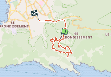

Length
15.2 km

Max alt
272 m

Uphill gradient
335 m
Km-Effort
20 km

Min alt
46 m

Downhill gradient
452 m
Boucle
No
Creation date :
2024-03-19 09:47:16.446
Updated on :
2024-03-19 14:59:02.884
5h11
Difficulty : Very difficult

FREE GPS app for hiking
 SityTrail
IGN / Geographical institutes
SityTrail Plus
The world is yours!
About
Trail Walking of 15.2 km to be discovered at Provence-Alpes-Côte d'Azur, Bouches-du-Rhône, Marseille. This trail is proposed by Jack-94.
Positioning
Country:
France
Region :
Provence-Alpes-Côte d'Azur
Department/Province :
Bouches-du-Rhône
Municipality :
Marseille
Location:
9th Arrondissement
Start:(Dec)
Start:(UTM)
697539 ; 4789376 (31T) N.
Comments