


Combe Chapon-fond de Beaulieu

crocau
User

Length
12.6 km

Max alt
325 m

Uphill gradient
158 m
Km-Effort
14.7 km

Min alt
225 m

Downhill gradient
162 m
Boucle
Yes
Creation date :
2024-03-20 15:35:03.705
Updated on :
2024-03-20 17:06:29.636
1h23
Difficulty : Very easy

FREE GPS app for hiking
 SityTrail
IGN / Geographical institutes
SityTrail Plus
The world is yours!
About
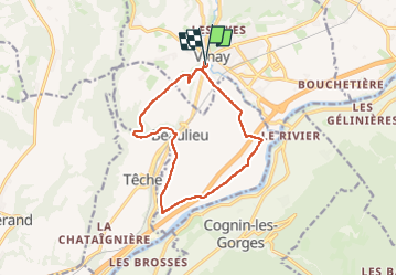
Trail Mountain bike of 12.6 km to be discovered at Auvergne-Rhône-Alpes, Isère, Vinay. This trail is proposed by crocau.
Photos


Positioning
Country:
France
Region :
Auvergne-Rhône-Alpes
Department/Province :
Isère
Municipality :
Vinay
Location:
Unknown
Start:(Dec)
Start:(UTM)
688476 ; 5008931 (31T) N.
Comments