


HOUBLONNIIERE 2015 N°12

cath310
User
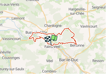

Length
26 km

Max alt
291 m

Uphill gradient
473 m
Km-Effort
32 km

Min alt
160 m

Downhill gradient
471 m
Boucle
No
Creation date :
2015-03-23 00:00:00.0
Updated on :
2015-03-23 00:00:00.0
6h54
Difficulty : Unknown

FREE GPS app for hiking
 SityTrail
IGN / Geographical institutes
SityTrail Plus
The world is yours!
About
Trail Walking of 26 km to be discovered at Grand Est, Meuse, Fains-Véel. This trail is proposed by cath310.
Description
houblonnière 2015
au départ de FAINS-LES-SOURCES 55000
Positioning
Country:
France
Region :
Grand Est
Department/Province :
Meuse
Municipality :
Fains-Véel
Location:
Unknown
Start:(Dec)
Start:(UTM)
655625 ; 5406791 (31U) N.
Comments
super car chemins bien sec !