


Boucle du col de Tamié en partant de Mercury

franquen
User
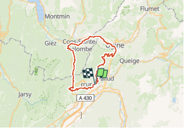

Length
50 km

Max alt
921 m

Uphill gradient
1317 m
Km-Effort
68 km

Min alt
363 m

Downhill gradient
1325 m
Boucle
Yes
Creation date :
2024-03-21 09:27:09.911
Updated on :
2024-03-21 18:13:05.773
5h16
Difficulty : Easy

FREE GPS app for hiking
 SityTrail
IGN / Geographical institutes
SityTrail Plus
The world is yours!
About
Trail Mountain bike of 50 km to be discovered at Auvergne-Rhône-Alpes, Savoy, Mercury. This trail is proposed by franquen.
Positioning
Country:
France
Region :
Auvergne-Rhône-Alpes
Department/Province :
Savoy
Municipality :
Mercury
Location:
Unknown
Start:(Dec)
Start:(UTM)
294958 ; 5061276 (32T) N.
Comments