


Chantemerle

thonyc
User GUIDE
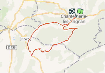

Length
8.5 km

Max alt
322 m

Uphill gradient
170 m
Km-Effort
10.8 km

Min alt
209 m

Downhill gradient
170 m
Boucle
Yes
Creation date :
2024-03-21 17:48:32.613
Updated on :
2024-03-21 17:49:06.841
2h27
Difficulty : Easy

FREE GPS app for hiking
 SityTrail
IGN / Geographical institutes
SityTrail Plus
The world is yours!
About
Trail On foot of 8.5 km to be discovered at Auvergne-Rhône-Alpes, Drôme, Chantemerle-lès-Grignan. This trail is proposed by thonyc.
Positioning
Country:
France
Region :
Auvergne-Rhône-Alpes
Department/Province :
Drôme
Municipality :
Chantemerle-lès-Grignan
Location:
Unknown
Start:(Dec)
Start:(UTM)
646268 ; 4918303 (31T) N.
Comments