


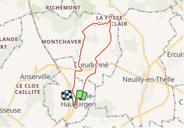
Puiseux le Hauberger_La Fosse St Clair_Trace GPS simplifiée_10,2Km

Pousscailleux
User

Length
11.1 km

Max alt
161 m

Uphill gradient
193 m
Km-Effort
13.7 km

Min alt
62 m

Downhill gradient
194 m
Boucle
Yes
Creation date :
2015-03-24 00:00:00.0
Updated on :
2015-03-24 00:00:00.0
2h53
Difficulty : Medium

FREE GPS app for hiking
 SityTrail
IGN / Geographical institutes
SityTrail Plus
The world is yours!
About
Trail Walking of 11.1 km to be discovered at Hauts-de-France, Oise, Puiseux-le-Hauberger. This trail is proposed by Pousscailleux.
Description
Départ le long de la "Grande Rue", près de l'église de Puiseux.
Itinéraire établi d'après le dépliant "Pays de Thelle, Côté Nature - Randonnée, Circuit Puiseux - Dieudonné"
Positioning
Country:
France
Region :
Hauts-de-France
Department/Province :
Oise
Municipality :
Puiseux-le-Hauberger
Location:
Unknown
Start:(Dec)
Start:(UTM)
444325 ; 5451393 (31U) N.
Comments