


menil -st aubin

lilys55
User
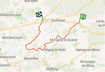

Length
20 km

Max alt
409 m

Uphill gradient
475 m
Km-Effort
27 km

Min alt
273 m

Downhill gradient
460 m
Boucle
No
Creation date :
2024-03-23 08:24:04.935
Updated on :
2024-03-23 08:24:30.998
3h30
Difficulty : Medium

FREE GPS app for hiking
 SityTrail
IGN / Geographical institutes
SityTrail Plus
The world is yours!
About
Trail Horseback riding of 20 km to be discovered at Grand Est, Meuse, Ménil-la-Horgne. This trail is proposed by lilys55.
Positioning
Country:
France
Region :
Grand Est
Department/Province :
Meuse
Municipality :
Ménil-la-Horgne
Location:
Unknown
Start:(Dec)
Start:(UTM)
686013 ; 5397525 (31U) N.
Comments