


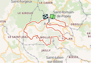
SityTrail - ANCY par les crêtes au Nord-Est des Monts du Lyonnais

Dan69
User

Length
19.4 km

Max alt
771 m

Uphill gradient
722 m
Km-Effort
29 km

Min alt
435 m

Downhill gradient
722 m
Boucle
Yes
Creation date :
2024-03-23 11:20:43.626
Updated on :
2024-04-10 16:44:42.833
6h35
Difficulty : Difficult

FREE GPS app for hiking
 SityTrail
IGN / Geographical institutes
SityTrail Plus
The world is yours!
About
Trail Walking of 19.4 km to be discovered at Auvergne-Rhône-Alpes, Rhône, Ancy. This trail is proposed by Dan69.
Description
D/A : depuis le parking indiqué et situé à la sortie du village à gauche en venant de Savigny - Saint-Bel. Prendre à gauche la rue centrale, rejoindre le bourg et la mairie
Positioning
Country:
France
Region :
Auvergne-Rhône-Alpes
Department/Province :
Rhône
Municipality :
Ancy
Location:
Unknown
Start:(Dec)
Start:(UTM)
617368 ; 5077270 (31T) N.
Comments