


margerides Fred B C

arnoultjf
User
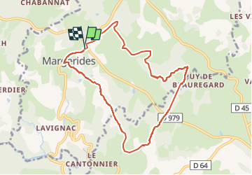

Length
9 km

Max alt
690 m

Uphill gradient
202 m
Km-Effort
11.7 km

Min alt
609 m

Downhill gradient
196 m
Boucle
Yes
Creation date :
2024-03-26 12:24:40.368
Updated on :
2024-03-28 07:14:38.332
2h39
Difficulty : Medium

FREE GPS app for hiking
 SityTrail
IGN / Geographical institutes
SityTrail Plus
The world is yours!
About
Trail Walking of 9 km to be discovered at New Aquitaine, Corrèze, Margerides. This trail is proposed by arnoultjf.
Description
7
Positioning
Country:
France
Region :
New Aquitaine
Department/Province :
Corrèze
Municipality :
Margerides
Location:
Unknown
Start:(Dec)
Start:(UTM)
453420 ; 5033666 (31T) N.
Comments