


Meursac EDF

JeanLuc17
User
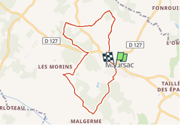

Length
8.3 km

Max alt
39 m

Uphill gradient
65 m
Km-Effort
9.2 km

Min alt
16 m

Downhill gradient
64 m
Boucle
Yes
Creation date :
2024-03-26 17:47:32.008
Updated on :
2024-03-26 17:48:08.553
2h05
Difficulty : Medium

FREE GPS app for hiking
 SityTrail
IGN / Geographical institutes
SityTrail Plus
The world is yours!
About
Trail Walking of 8.3 km to be discovered at New Aquitaine, Charente-Maritime, Meursac. This trail is proposed by JeanLuc17.
Positioning
Country:
France
Region :
New Aquitaine
Department/Province :
Charente-Maritime
Municipality :
Meursac
Location:
Unknown
Start:(Dec)
Start:(UTM)
670654 ; 5057413 (30T) N.
Comments