


LES TROIS MONTS (MAZENAY, 24 Km, 830 m d+).

DUCLUZEAU
User
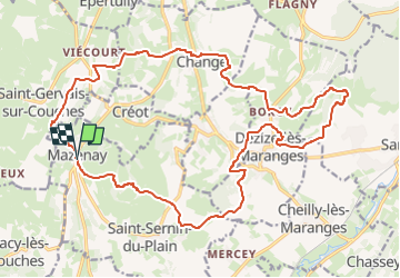

Length
23 km

Max alt
542 m

Uphill gradient
830 m
Km-Effort
34 km

Min alt
259 m

Downhill gradient
828 m
Boucle
Yes
Creation date :
2024-03-27 04:32:41.896
Updated on :
2024-03-27 04:33:29.294
7h49
Difficulty : Difficult

FREE GPS app for hiking
 SityTrail
IGN / Geographical institutes
SityTrail Plus
The world is yours!
About
Trail Walking of 23 km to be discovered at Bourgogne-Franche-Comté, Saône-et-Loire, Saint-Sernin-du-Plain. This trail is proposed by DUCLUZEAU.
Positioning
Country:
France
Region :
Bourgogne-Franche-Comté
Department/Province :
Saône-et-Loire
Municipality :
Saint-Sernin-du-Plain
Location:
Unknown
Start:(Dec)
Start:(UTM)
621545 ; 5196197 (31T) N.
Comments