


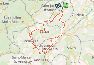
Boucle du lac du Ternay au départ de Brossainc

d.rognon
User

Length
17.2 km

Max alt
706 m

Uphill gradient
556 m
Km-Effort
25 km

Min alt
466 m

Downhill gradient
556 m
Boucle
Yes
Creation date :
2024-03-27 07:12:25.744
Updated on :
2024-03-27 07:18:23.712
5h35
Difficulty : Very difficult

FREE GPS app for hiking
 SityTrail
IGN / Geographical institutes
SityTrail Plus
The world is yours!
About
Trail Walking of 17.2 km to be discovered at Auvergne-Rhône-Alpes, Ardèche, Brossainc. This trail is proposed by d.rognon.
Points of interest


Positioning
Country:
France
Region :
Auvergne-Rhône-Alpes
Department/Province :
Ardèche
Municipality :
Brossainc
Location:
Unknown
Start:(Dec)
Start:(UTM)
631583 ; 5021061 (31T) N.
Comments