


montée bois de St Jacques . traversée par sart aux fraises . descente ruisseau de kinkempois

stef789
User GUIDE
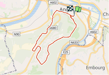

Length
7.5 km

Max alt
239 m

Uphill gradient
237 m
Km-Effort
10.7 km

Min alt
69 m

Downhill gradient
245 m
Boucle
Yes
Creation date :
2024-03-28 14:31:12.98
Updated on :
2024-03-28 16:20:55.66
1h49
Difficulty : Easy

FREE GPS app for hiking
 SityTrail
IGN / Geographical institutes
SityTrail Plus
The world is yours!
About
Trail Walking of 7.5 km to be discovered at Wallonia, Liège, Liège. This trail is proposed by stef789.
Photos


Positioning
Country:
Belgium
Region :
Wallonia
Department/Province :
Liège
Municipality :
Liège
Location:
Angleur
Start:(Dec)
Start:(UTM)
683839 ; 5609721 (31U) N.
Comments