Nouveau Latay by Gege 2

giovannoni
User
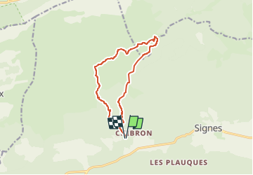

Length
12.4 km

Max alt
667 m

Uphill gradient
279 m
Km-Effort
16.2 km

Min alt
424 m

Downhill gradient
278 m
Boucle
Yes
Creation date :
2024-03-30 08:44:59.933
Updated on :
2024-03-30 08:45:00.657
3h40
Difficulty : Difficult

FREE GPS app for hiking
 SityTrail
IGN / Geographical institutes
SityTrail Plus
The world is yours!
About
Trail Walking of 12.4 km to be discovered at Provence-Alpes-Côte d'Azur, Var, Signes. This trail is proposed by giovannoni.
Positioning
Country:
France
Region :
Provence-Alpes-Côte d'Azur
Department/Province :
Var
Municipality :
Signes
Location:
Unknown
Start:(Dec)
Start:(UTM)
729053 ; 4796597 (31T) N.
Comments