


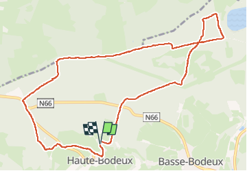
haute bodeux . lac supérieur coo . ancienne barrière

stef789
User GUIDE

Length
11.1 km

Max alt
506 m

Uphill gradient
231 m
Km-Effort
14.1 km

Min alt
395 m

Downhill gradient
233 m
Boucle
Yes
Creation date :
2024-03-30 13:29:28.127
Updated on :
2024-03-30 16:55:05.576
3h25
Difficulty : Easy

FREE GPS app for hiking
 SityTrail
IGN / Geographical institutes
SityTrail Plus
The world is yours!
About
Trail Walking of 11.1 km to be discovered at Wallonia, Liège, Trois-Ponts. This trail is proposed by stef789.
Description
tracé modifié pour éviter le trop plein d asphalte...
Photos


33 photos in total. Please click on a photo to see them all in the gallery.
Positioning
Country:
Belgium
Region :
Wallonia
Department/Province :
Liège
Municipality :
Trois-Ponts
Location:
Unknown
Start:(Dec)
Start:(UTM)
699437 ; 5582514 (31U) N.
Comments