


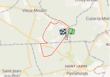
Etangs de St Pierre_Mont Arcy_9,9 km

Pousscailleux
User

Length
9.9 km

Max alt
91 m

Uphill gradient
96 m
Km-Effort
11.1 km

Min alt
48 m

Downhill gradient
93 m
Boucle
Yes
Creation date :
2015-03-26 00:00:00.0
Updated on :
2015-03-26 00:00:00.0
3h23
Difficulty : Medium

FREE GPS app for hiking
 SityTrail
IGN / Geographical institutes
SityTrail Plus
The world is yours!
About
Trail Walking of 9.9 km to be discovered at Hauts-de-France, Oise, Vieux-Moulin. This trail is proposed by Pousscailleux.
Description
Départ du parking des Etangs de Saint Pierre.
Positioning
Country:
France
Region :
Hauts-de-France
Department/Province :
Oise
Municipality :
Vieux-Moulin
Location:
Unknown
Start:(Dec)
Start:(UTM)
497599 ; 5468923 (31U) N.
Comments