


st privat Monistrl ven matin

any1950
User
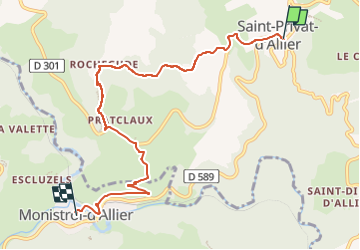

Length
7.6 km

Max alt
951 m

Uphill gradient
140 m
Km-Effort
10.3 km

Min alt
592 m

Downhill gradient
404 m
Boucle
No
Creation date :
2024-04-03 12:22:46.678
Updated on :
2024-04-03 12:23:27.704
2h20
Difficulty : Medium

FREE GPS app for hiking
 SityTrail
IGN / Geographical institutes
SityTrail Plus
The world is yours!
About
Trail Walking of 7.6 km to be discovered at Auvergne-Rhône-Alpes, Haute-Loire, Saint-Privat-d'Allier. This trail is proposed by any1950.
Positioning
Country:
France
Region :
Auvergne-Rhône-Alpes
Department/Province :
Haute-Loire
Municipality :
Saint-Privat-d'Allier
Location:
Saint-Privat-d'Allier
Start:(Dec)
Start:(UTM)
553559 ; 4982030 (31T) N.
Comments