


Rando port au cerise - Ablon 18km

jeanmarcMasson
User GUIDE
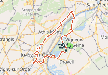

Length
18.1 km

Max alt
85 m

Uphill gradient
225 m
Km-Effort
21 km

Min alt
29 m

Downhill gradient
226 m
Boucle
Yes
Creation date :
2024-04-03 07:33:38.085
Updated on :
2024-04-03 13:48:28.102
4h28
Difficulty : Very difficult

FREE GPS app for hiking
 SityTrail
IGN / Geographical institutes
SityTrail Plus
The world is yours!
About
Trail Walking of 18.1 km to be discovered at Ile-de-France, Essonne, Draveil. This trail is proposed by jeanmarcMasson.
Positioning
Country:
France
Region :
Ile-de-France
Department/Province :
Essonne
Municipality :
Draveil
Location:
Unknown
Start:(Dec)
Start:(UTM)
456409 ; 5393434 (31U) N.
Comments