


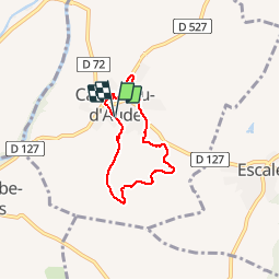
11-Castelnau d'Aude (Aude)

Jovila
User

Length
5.7 km

Max alt
105 m

Uphill gradient
82 m
Km-Effort
6.7 km

Min alt
59 m

Downhill gradient
81 m
Boucle
Yes
Creation date :
2017-02-24 00:00:00.0
Updated on :
2017-02-24 00:00:00.0
1h22
Difficulty : Very easy

FREE GPS app for hiking
 SityTrail
IGN / Geographical institutes
SityTrail Plus
The world is yours!
About
Trail Walking of 5.7 km to be discovered at Occitania, Aude, Castelnau-d'Aude. This trail is proposed by Jovila.
Description
Randonnée très bien balisée.
Panneau d'indications au départ (durée de la rando 2 h 30), nous l'avons effectuée en 1 h 20 en visitant la chapelle au cimetière et en prenant des photos !!!!
Positioning
Country:
France
Region :
Occitania
Department/Province :
Aude
Municipality :
Castelnau-d'Aude
Location:
Unknown
Start:(Dec)
Start:(UTM)
473424 ; 4786384 (31T) N.
Comments