


Autichamp

raygautier
User
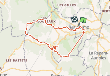

Length
18.9 km

Max alt
449 m

Uphill gradient
478 m
Km-Effort
25 km

Min alt
254 m

Downhill gradient
475 m
Boucle
Yes
Creation date :
2024-04-04 06:25:21.0
Updated on :
2024-04-05 04:37:13.586

FREE GPS app for hiking
 SityTrail
IGN / Geographical institutes
SityTrail Plus
The world is yours!
About
Trail of 18.9 km to be discovered at Auvergne-Rhône-Alpes, Drôme, Autichamp. This trail is proposed by raygautier.
Positioning
Country:
France
Region :
Auvergne-Rhône-Alpes
Department/Province :
Drôme
Municipality :
Autichamp
Location:
Unknown
Start:(Dec)
Start:(UTM)
655688 ; 4949485 (31T) N.
Comments