Le Bleymard_La Crouzette par le chemin Stevenson_10,5Km

Pousscailleux
User
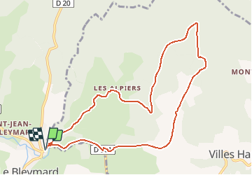

Length
10.6 km

Max alt
1288 m

Uphill gradient
285 m
Km-Effort
14.4 km

Min alt
1070 m

Downhill gradient
285 m
Boucle
Yes
Creation date :
2015-03-27 00:00:00.0
Updated on :
2015-03-27 00:00:00.0
3h02
Difficulty : Difficult

FREE GPS app for hiking
 SityTrail
IGN / Geographical institutes
SityTrail Plus
The world is yours!
About
Trail Walking of 10.6 km to be discovered at Occitania, Lozère, Mont Lozère et Goulet. This trail is proposed by Pousscailleux.
Description
Départ du parking de la supérette à l'entrée du Bleymard
Positioning
Country:
France
Region :
Occitania
Department/Province :
Lozère
Municipality :
Mont Lozère et Goulet
Location:
Le Bleymard
Start:(Dec)
Start:(UTM)
558886 ; 4926621 (31T) N.
Comments