


Enregistrement du 07/04/2024 10:42

Didier Gason
User
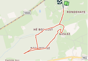

Length
4.2 km

Max alt
337 m

Uphill gradient
116 m
Km-Effort
5.8 km

Min alt
240 m

Downhill gradient
116 m
Boucle
Yes
Creation date :
2024-04-07 08:42:55.014
Updated on :
2024-04-07 12:16:40.013

FREE GPS app for hiking
 SityTrail
IGN / Geographical institutes
SityTrail Plus
The world is yours!
About
Trail of 4.2 km to be discovered at Wallonia, Liège, Theux. This trail is proposed by Didier Gason.
Description
Un enregistrement de randonnée réalisé avec SityTrail.
Positioning
Country:
Belgium
Region :
Wallonia
Department/Province :
Liège
Municipality :
Theux
Location:
Theux
Start:(Dec)
Start:(UTM)
697300 ; 5602945 (31U) N.
Comments