


pascaloune

brandy
User
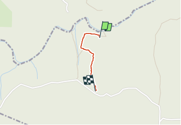

Length
605 m

Max alt
346 m

Uphill gradient
79 m
Km-Effort
1.4 km

Min alt
265 m

Downhill gradient
0 m
Boucle
No
Creation date :
2024-04-07 16:14:34.792
Updated on :
2024-04-07 16:42:14.111
18m
Difficulty : Easy

FREE GPS app for hiking
 SityTrail
IGN / Geographical institutes
SityTrail Plus
The world is yours!
About
Trail Walking of 605 m to be discovered at Auvergne-Rhône-Alpes, Ardèche, Saint-Montan. This trail is proposed by brandy.
Positioning
Country:
France
Region :
Auvergne-Rhône-Alpes
Department/Province :
Ardèche
Municipality :
Saint-Montan
Location:
Unknown
Start:(Dec)
Start:(UTM)
625297 ; 4919518 (31T) N.
Comments