


plateau st barnabe
© OpenStreetMap contributors


3h07
Difficulty : Difficult


Length
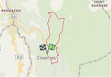
8.5 km
Max alt
961 m
Uphill gradient
397 m
Km-Effort
13.8 km
Min alt
622 m
Downhill gradient
384 m
Boucle
Yes
Creation date :
2024-04-09 14:14:07.182
Updated on :
2024-04-09 14:25:37.415
3h07
Difficulty : Difficult
FREE GPS app for hiking
 SityTrail
IGN / Geographical institutes
SityTrail Plus
The world is yours!
About
Trail Walking of 8.5 km to be discovered at Provence-Alpes-Côte d'Azur, Maritime Alps, Courmes. This trail is proposed by Denis Danielle Berthier.
Description
courmes
Positioning
Country:
France
Region :
Provence-Alpes-Côte d'Azur
Department/Province :
Maritime Alps
Municipality :
Courmes
Location:
Unknown
Start:(Dec)
Start:(UTM)
339692 ; 4845346 (32T) N.
Comments