


Boule d’amont /Chapelle de la Trinité / Prunet

robertperello
User
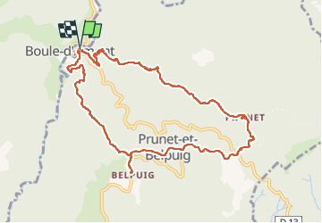

Length
11.2 km

Max alt
685 m

Uphill gradient
358 m
Km-Effort
16 km

Min alt
413 m

Downhill gradient
360 m
Boucle
Yes
Creation date :
2024-04-10 07:47:28.0
Updated on :
2024-04-10 12:36:00.901
3h06
Difficulty : Easy

FREE GPS app for hiking
 SityTrail
IGN / Geographical institutes
SityTrail Plus
The world is yours!
About
Trail Walking of 11.2 km to be discovered at Occitania, Pyrénées-Orientales, Prunet-et-Belpuig. This trail is proposed by robertperello.
Description
Pking après Lo serrât
Photos


Positioning
Country:
France
Region :
Occitania
Department/Province :
Pyrénées-Orientales
Municipality :
Prunet-et-Belpuig
Location:
Unknown
Start:(Dec)
Start:(UTM)
468468 ; 4714225 (31T) N.
Comments