


Table du roi - 19 km

jeanmarcMasson
User GUIDE
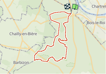

Length
18.9 km

Max alt
152 m

Uphill gradient
253 m
Km-Effort
22 km

Min alt
81 m

Downhill gradient
253 m
Boucle
Yes
Creation date :
2024-04-10 07:45:14.113
Updated on :
2024-04-10 13:46:07.138
4h13
Difficulty : Very difficult

FREE GPS app for hiking
 SityTrail
IGN / Geographical institutes
SityTrail Plus
The world is yours!
About
Trail Walking of 18.9 km to be discovered at Ile-de-France, Seine-et-Marne, Fontainebleau. This trail is proposed by jeanmarcMasson.
Photos


Positioning
Country:
France
Region :
Ile-de-France
Department/Province :
Seine-et-Marne
Municipality :
Fontainebleau
Location:
Unknown
Start:(Dec)
Start:(UTM)
475244 ; 5370021 (31U) N.
Comments