


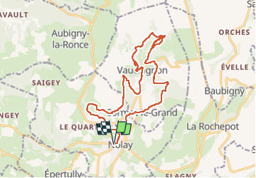
nolay

Montagne71
User

Length
18.9 km

Max alt
519 m

Uphill gradient
693 m
Km-Effort
28 km

Min alt
328 m

Downhill gradient
694 m
Boucle
Yes
Creation date :
2024-04-11 07:34:01.703
Updated on :
2024-04-11 14:11:49.547
6h01
Difficulty : Medium

FREE GPS app for hiking
 SityTrail
IGN / Geographical institutes
SityTrail Plus
The world is yours!
About
Trail Walking of 18.9 km to be discovered at Bourgogne-Franche-Comté, Côte-d'Or, Nolay. This trail is proposed by Montagne71.
Description
belle rando, bout du monde, beau temps.
Positioning
Country:
France
Region :
Bourgogne-Franche-Comté
Department/Province :
Côte-d'Or
Municipality :
Nolay
Location:
Unknown
Start:(Dec)
Start:(UTM)
624049 ; 5201089 (31T) N.
Comments